Wednesday, December 31, 2014

Things Found in the Woods - 1

Part of being a scientist is about being observant of one's surroundings, so from time-to-time I may include things out of the realm of geology.

Photography of mushrooms (and things related) has been a hobby of mine for a while. When I walked into our backyard a few days ago, I noticed this "yellow stuff" on some lichen-encrusted tree limbs on the ground.

Checking one of my reference books, I found a photo of "Witches Butter", another name for which is yellow brain fungus. Supposedly it is edible and I believe I saw some reference to Witches Butter Soup. But of course, don't use my identifications as an OK to go ahead and eat anything that looks like this.

The name sounds like something out of a Harry Potter movie, perhaps a potion ingredient.

A Ptiny Pterodactyl! (early 2008)

One never knows what one will find at Free Republic.

While web/blog surfing today, I found a post on the discovery of a tiny Jurassic pterosaur, in northeastern China in the western part of the Liaoning Province. The wingspan of the young critter, Nemicolopterus crypticus, was about 10 inches.

The original Live Science article suggests that the ptiny pterosaur (which may have been a juvenile), was of the a same "family tree" as Quetzalcoatlus, which boasted a wingspan of more than 30 feet. BTW, Quetzacoatlus was first discovered in Texas, as one might expect.

What a Geologist Sees - Part 16

Before you conclude that I have completely lost my mind, it is an old toaster, circa 1930s.

I included this photo in this series to show the sheets of muscovite mica behind the center electrodes. This illustrates one of the uses of muscovite, as an electrical insulator. You can also find mica used in the newer, vertical-type toasters.

[While showing this to one of the teachers at my junior college campus, he remarked that there is an organization devoted to collecting old toasters. I asked him whether the toaster collectors got "toasted" during their social events at their shows.]

In general, if you have a rock with small, aligned mica flakes, it is probably a metamorphic rock, such as a schist. If the mica flakes are larger than 3/4 inch across, it is probably an igneous rock.

Because of the "flaky" nature of mica, large pieces are known as "books" and they usually occur in irregular igneous intrusions called "pegmatites". Mica books 5 feet in diameter have been mined in Georgia pegmatites in the past. If memory serves me correctly, mica has been mined in the Ball Ground, Thomaston, and La Grange areas of Georgia, as well as several places in western North Carolina. Pegmatites also include many other interesting minerals.

Synthetic mica has been in production for more than 50 years, making mining mica less of a necessity.

What a Geologist Sees - Part 17


I am generally a "mountains and desert" person, but when I do go to the beach, I always like to get some photos of ripple marks and other "sedimentary structures".

Ripple marks and the raindrop impressions are actually termed "external sedimentary structures", as this is what we see when we see the top of a sedimentary layer.

I have seen numerous examples of ripple marks preserved in the "rock record" in sandstones, but I have not seem them combined with raindrop impressions. Usually, when we see symmetrical ripples in a sandstone, it is indicative of a beach environment, where the ripples and raindrops can be obscured by the next storm tides or the next heavy rains, while the sand was still soft and unconsolidated.

I have seen ripples with rain-drop impressions in red siltstones (finer-grained than the sandstones), which were deposited in a tidal flat setting. Sometimes in those cases, after the exposed layer had dried and hardened somewhat, it was covered over and preserved by the next layer.

[So while I may look at the pretty girls, I am taking photos of clouds, waves, ripple marks, and sand dunes, so as not to be labeled a "dirty old man".]

What a Geologist Sees - Part 18

Is this the world's smallest volcano? Maybe. [See the rock hammer for scale.]

This is a small example of a volcanic spatter vent. Usually spatter vents are late-stage events in the life cycle of an eruption, as the volcano is "losing its punch."

This spatter vent and the spatter mound shown below are just a couple of small, yet interesting features of the Aden Basalt Flows, which are part of the Potrillo Volcanic Field in southern Doña Ana County, New Mexico. The cinder cones of the northern parts of the Potrillo Volcanic Field are visible to the south of I-10, west of Las Cruces, New Mexico. Kilbourne's Hole, discussed in What a Geologist Sees - Part 13, is also part of the Potrillo Volcanic Field.

Most of the Aden Basalt flows are the result of fissure eruptions (lava flows erupted from open fractures in the ground surface), except in the northwestern part of the Aden Basalts, where Aden Crater (a small shield volcano) is present. Aden Crater is thought to have formed after the bulk of the fissure eruptions. Aden Crater (the subject of a future post) lies at the probable intersection of the Robledo Fault and the Aden Volcanic Rift (a buried fracture zone).

Spatter vents erupt by spitting small to moderate clots of partially solidified basalt (of the consistency of taffy).


The lower photo is of a mound of spatter material within Aden Crater itself. The stadia rod (used in mapping), leaning against the right side of the spatter mound, is about 6 feet long (for scale).

These are just a few of the many interesting volcanic features to be found in the Aden Basalts. Many typical features of basaltic vulcanism are preserved in the Potrillo Volcanic Field, along with some oddities that have not been seen elsewhere (for another post).

In another future post, I will show some different types of volcanic "ejecta" (aka volcanic bombs), which are found associated with some of the volcanoes of the Potrillo Volcanic Field. Just a suggestion, if you ever drive out into this area, carry plenty of water, have a good map, and let someone know where you are going.

What a Geologist Sees - Part 19


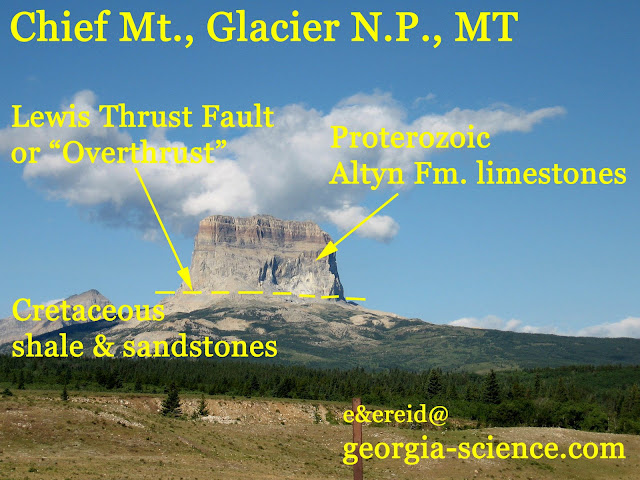
Glacier National Park is one of the "Bucket List" places that I hope to visit, someday.

[For the moment, a photo taken by a friend will have to suffice until I can get there to take my own.]

The feature pictured at right is Chief Mountain, which consists of Proterozoic limestones sitting atop Cretaceous shale and sandstones. This is totally "out-of-whack" with "what should be". Under normal conditions, the Concept of Superposition applies, wherein in a series of layered rocks (usually sedimentary, but could apply to some volcanics), the oldest layers are at the bottom and the youngest are at the top. The Proterozoic is much older than the Cretaceous.

The presence of a "thrust fault" is the reason for the existing condition. During periods of tectonic deformation, where there is lateral compression, sometimes sheets of rock will break loose and get "shoved on top of" younger layers. The lateral breakage is usually along a shale layer. In this case, the thrust fault is referred to as the Lewis Thrust Fault or the Lewis Overthrust. Erosion after the period of faulting isolated Chief Mt. from the remainder of the thrust sheet, thus we call Chief Mt. a "klippe", which is a type of "erosional outlier", i.e., it is laterally separated from similar rocks.

The mesas and buttes of Monument Valley are also erosional outliers, but they have no underlying thrust fault, so they are not klippes.

There are plenty of thrust faults in the Appalachians, including the Georgia Piedmont, though they are obscured by soil and vegetation cover. There is a thrust fault (name forgotten) exposed in an outcrop on the west side of I-285, north of the intersection with I-20 and near the Chattahoochee River, but the traffic makes it difficult to pull over and get a good photo.

There is a Georgia Piedmont Thrust Fault, shown in Figure 9, of this post.

Tuesday, December 30, 2014

What a Geologist Sees - Part 20

[Back to our regularly-scheduled program. As referenced here, Stratigraphy is the study of layered rocks.]

Monument Valley, which straddles the AZ/UT border, is one of those places on my Top-10 Want-to-Visit List (which will be the subject of a later post).

In the course of my classes, whether they be Environmental Science or Geology, I remind my students that in the future, if they do a little "homework" before traveling, they will enjoy the trip more. Especially if they have kids to entertain.

To a non-scientist, it might seem that thinking about the geology might distract from the enjoyment of the natural and stark beauty, but to me it doesn't. To me, visualizing about "what it used to look like" at various points in geologic history adds to the wonder. To address the subject of the first photo (actually all three slides were taken by my Dad in 1980), the mesas, buttes, and most of the spires of Monument Valley are remnants of a formerly-continuous sheet of Permian and Triassic sedimentary rocks. The millions of years of weathering and erosion have brought forth the wonderous landforms we see, not only in Monument Valley, but elsewhere in the Colorado Plateau.

The four formations shown in the second photo are but a small portion of the "Colorado Plateau Stratigraphic Section", i.e., all of the layered rocks that occur within the defined area of the Colorado Plateau. [This USGS webpage lists all of the geologic units that occur within the Colorado Plateau, some of which only occur at the margins and extend into adjacent regions. This USGS webpage lists all of the National Parks and such that are present within the Colorado Plateau (and the Colorado River Basin). Monument Valley itself is not administered by the National Park Service.] A simple geographic definition of the Colorado Plateau, which covers 50,000 square miles, is presented here by Encarta. The Moenkopi and Organ Rock Formations are present to the north at Canyonlands National Park, while the de Chelly Sandstone is present to the south at Canyon de Chelly National Park. The Permian de Chelly Sandstone is derived from eolian sand-dune deposits. At Canyonlands, the White Rim Sandstone lies between the Moenkopi and the Organ Rock, thus making it the "Stratigraphic Equivalent" of the de Chelly, though the environment of deposition was different, suggested to be nearshore sand dunes for the White Rim.

In arid climates, topographic slopes are often defined by their underlying rock types in ways that are different from humid climates. The contrast between arid-climate "slope formers" and "cliff formers" is illustrated by the mesa (I think it is Sentinel Mesa) in the second photo. In arid climates, shales are "slope formers", while sandstones and limestones are "cliff formers". Alternating shales and sandstones/limestones produces a "stair-step effect", with the slope angle related to the percentage of shale vs. the other two rock types.

[I can give a more detailed description of why limestones behave differently in the contrasting climates, but that would take up more space.]

The third photo is of Agathla Peak, which is different from the other landforms in Monument Valley. It is an eroded "volcano neck", i.e., the central spire represents solidified magma within and/or below the original volcano. It is more resistant to erosion than the slope material that made up the flanks of the volcano. The volcano neck can also be referred to as a "feeder pipe". Shiprock is another good example of this type of landform. Agathla Peak is some 1,500 feet higher than the surrounding plateau.

[Additional info may be added later.]

600 Horsepower, 2800 lbs, 15-inch Wide Tires,... (Originally published 09/02/08)

[OK, it ain't Geology, but I reposted this for memories' sake.] 98 mph on a 3/8 mile track.

Yeah, that works! My son, son in-law, and I went to our local NASCAR sanctioned raceway on Saturday night. Yeah, we are rednecks of a fashion.

Along with shortened versions of the weekly divisions, there was a 150-lap touring event, this time by the Whelen Southern Modified Tour. Generally it is the touring series that provide drivers the chance to advance to the higher-profile NASCAR divisions.

Though it was raining when we reached the track, the rain soon ended and the late afternoon sun helped dry the track. During the wait, the raceway opened the gate and allowed the fans to walk among the racecars, greet the drivers and get autographs.

From the first two photos, you can see why they call them "Modifieds". The winning car, #28 is a Ford-based body, while the #07 of second place of Frank Fleming, is a Chevy. No pretext of "stock" here.

In the past, this type of racecar was the training ground for Bobby Allison, the Bodine brothers, Ron Bouchard, and Jimmy Spencer, all of which won races in what is now called the NASCAR Sprint Cup Series (or the Craftsman Truck Series) . Bobby Allison won the 1983 Sprint Cup (nee' Winston Cup) series along with 80 some-odd Sprint Cup events.

The last photo is of George Brunnhoelzl III, celebrating his first series win with his dad, in Victory Lane. Would AA-level baseball parks have opened the field before or after the game for fans to greet the players or for fans to photograph a post-game interview of the winning pitcher? We will get some sort of idea next year as the AAA Richmond Braves are becoming the AAA Gwinnett Braves.

George Brunnhoelzl III is a third-generation race car driver from Babylon, NY. For anyone interested, here is more info on the race and the results. So instead of fretting about the costs of major league sporting events or the traffic, find a "farm system" event, where you may see future stars on their way. Both my son and daughter have seen drivers at this track that have gone on to run NASCAR Nationwide Series and Craftsman Truck Series events.

What a Geologist Sees - Part 21 (Originally published 09/05/08)


Understanding the concept of Base Level is an important part of understanding the behavior of streams, erosion, and subaerial (terrestrial) stream deposition.

"Base Level" (mentioned briefly here) as a concept was defined by John Wesley Powell and is the lowest point to which a stream can erode at any one point. More info is presented here.


Figure 2.

Ultimate Base Level is Mean Sea Level, i.e., rivers and streams cannot erode any deeper than sea level.

Over geologic time, Ultimate Base Level changes with changes in sea level. The primary causes of Mean Sea Level are variations in polar icecap coverage (more ice = lower sea level) and variations in plate-tectonics oceanic rift zone activity. 

When rift zones are more active, the seafloor is bulged upwards by the rising mantle plumes, which displaces seawater and raises sea level. When rift zone activity slows, sea level drops. Add to this local changes in the elevation of continental margins. When the edge of a continent rises, that mimics a sea-level drop (aka a Regression) and vice versa when the edge of a continent sinks, that mimics a sea-level rise (aka a Transgression).

When the Ultimate Base Level rises, the "Ultimate Stream Gradient" (from the ultimate stream/river source) is decreased, resulting in more deposition. There will be deposition also in any "drowned" portions of previously exposed river systems. When Ultimate Base Level drops, the Ultimate Stream Gradient increases (steepens), resulting in more erosion.

Within every river and creek system, there are innumerable "Local Base Levels", points below which the upstream river (or creek) cannot erode. Local Base Level controls the upstream gradient on that particular river/creek until the next higher-elevation Local Base Level.

In the second photo, there is a small example of a Local Base Level, established by this small outcrop in Chickamauga Battlefield Park, Georgia. Upstream from this locally resistant outcrop, the stream is prevented from down-cutting any further. The next ledge or another outcrop upstream then establishes the next upstream Local Base Level.

As changes in sea level affect the Ultimate Base Level and the Ultimate Gradient, changes in a Local Base Level affects Local Stream Gradients. When a dam is constructed (or when a landslide naturally forms a pond/lake), that raises the Local Base Level, resulting in more deposition. 

When Lake Lanier was constructed a little more than 50 years ago, the rising "pool elevation" raised the Local Base Level of all streams entering the lake. In the upper photo, you see the exposed lake-bottom sediments, contributed by local hillside erosion and by deposition of sediments contributed by this particular small stream, over the course of 50 years.

When the extended drought and dam releases caused a lowering of the pool elevation, that lowered the Local Base Level and resulted in the few inches of erosion (down-cutting) that you see in the upper photo. When the lake returns to its Full-Pool elevation, the upstream Local Base Levels will again rise and down-cutting will cease and sedimentation will resume.

There are characteristic stream behaviors that are affected by the steepness of the stream gradient (Ultimate and Local). When you have a steep gradient (low Ultimate Base Level or Local Base Level), you have more down-cutting in the stream valleys. When the Base Level suddenly rises, the upstream valleys are "back-filled". Remember, subsidence of a continental margin can mimic a Base Level rise.

On Coastal Plains and River Deltas, where the gradient is very low, lateral erosion causes migration of the stream channels and the resulting meanders.  And usually, in this situation, you have wide floodplains and/or local low-relief topography. 

When you have a low-gradient feature, such as river meanders, in an area with great topographic relief, that can tell you of a rapid drop in Ultimate Base Level or a rapid uplift of the landmass, such as with the Colorado Plateau (discussed in the next post of this series) or with some other regional feature, such as the land surrounding the Black Canyon of the Gunnison River, in Colorado.

Changes in Local Base levels (including some caused by human activities) can have smaller-scale effects on local streams (as described above regarding Lake Lanier).

What a Geologist Sees - Part 22 (Originally published 10/10/08)


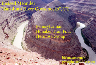
Most folks know a river or creek meander when they see one (or more).

Usually we see them in Coastal Plain settings or other places where the stream gradient (feet/mile drop in elevation) is low, especially if the materials underlying the stream are soft Coastal Plain sediments and/or floodplain deposits.

When a stream's gradient is steep, as in a mountain stream, there is a tendency for gravity to control erosion, i.e., the erosion is vertical - down-cutting as we call it. This vertical down-dutting (being slightly redundant) results in sharp "V"-shaped valleys, with no flood plains.

So when you see deeply-incised meanders, such as in the above photo, that suggests that the meanders were established under low-gradient conditions at a higher Base Level (see this post for an explanation of Base Level). Then a rapid drop in Base Level and/or a rapid uplift of the land "preserved" the meanders as the river cut downward through the Colorado Plateau sedimentary rock layers.
The Grand Canyon also illustrates this same rapid uplift/drop in Base Level, as does the area containing the Black Canyon of the Gunnison River, in Colorado, though without the meanders.

What a Geologist Sees - Part 23a (Originally published 10/10/08)

Providence Canyons, locally called "the Little Grand Canyon", in Stewart County, Georgia, provides a stark look at what can happen when erosion takes hold in an area underlain by a soft sand.


The canyons are generally on the order of 125 feet deep and are only perhaps 150 years old.


[I bring this up as our Boy Scout Troop is scheduled to camp and hike there this weekend.]


The supposed genesis of the canyons was due to rain running off the corner of a church and beginning a small gully. The surface of this area is locally covered by the residuum of the Paleocene-aged Clayton Limestone, which has been reduced to a iron-rich, reddish clay. One this clay veneer is breached by a gully, the underlying soft, deltaic sands of the Cretaceous Providence Sand. There is essentially nothing to stop the downward erosion or the widening of side canyons. At some point in the future, the area will probably reach some sort of equilibrium as a series of low sandy hills, separated by sand-clogged, braided streams.

As an aside, exposures of sand such as this serve as "recharge zones" for sand aquifers and elsewhere, the subsurface Providence Sand does serve as an aquifer.


What a Geologist Sees - Part 23b (Originally published 10/20/08)

As a follow-up to What a Geologist Sees - Part 23...

Here are a few photos from our Boy Scout trip to Providence Canyons State Park, in Stewart County, GA. It had changed a bit since my last visit, close to 30 years ago and I learned a few new things (Yeah, we old dogs can learn once in a while).

The canyons are not getting any deeper, they have "bottomed out" at about 150 feet deep, but they are continually getting wider, in some places 3 - 5 feet of rim are being lost per year. One park road had been abandoned as the rim approached. I don't really see any way to stop it.

My first trip to Providence Canyons, as a Georgia Southern undergrad, was about 35 years ago and it was part of a field trip to the area, so we didn't have time to hike down in the canyons themselves, this time we did hike up the braided stream deposits (third photo), then up to the visitor's center. From there we hiked around the rim. After stopping for lunch, another of the Assistant Scoutmasters and I left to go back to the visitor's center for a wildflower ID tour, so we missed going back down into the canyon to see the walls "up close and personal".

Some of the new things I learned were that in the Providence Formation, there are some kaolinitic clay beds within the delta sands; the underlying clays in the Ripley Formation are preventing the further downcutting in the canyons, and that Providence Canyons was one signature away from becoming a national park, back in the 1930s. The ranger didn't say who didn't sign on.

Some of the visitors suggested that some of the Providence Canyons features reminded them of Zion National Park (I haven't been there or to Bryce Canyon, so I couldn't say that one way or another). The main difference is that the Colorado Plateau sedimentary rocks are a little harder than the soft sands and clays of the Providence Formation, so Zion doesn't change as fast as Providence Canyons.

I do regret not stepping a few yards from the braided stream to the nearby bluff base to get some close-up photos of the Wild Pink Azaleas, which bloom in the spring and then again in the fall. The two shots I took weren't clear enough to keep.

If I do get to visit Providence Canyons again, I won't wait another 30 years.

What a Geologist Sees - Part 24 Weathering

(Previously published on December 17, 2010.  I republished it because understanding different modes of physical weathering is an important part of Physical Geology.  More time on Physical Weathering was spent on this post. from March 6, 2020.)

I am sure that many folks have seen rounded boulders before. Have you given much thought to how they got rounded?

One possibility is that the boulders were rounded in a river channel subject to "big ass" floods, necessary to move and abraid the boulders against each other.


But more often, the boulders are rounded in situ (in place) by a process called spheroidal weathering. On the Georgia Piedmont, most often we see spheroidal weathering in granites and granitic gneisses.

A couple of other places to see spheroidal weathering of granites is the I-10 rest stops in the Little Dragoon Mts. in Cochise County, southeastern Arizona (I think the westbound rest stop is the better of the two for photographs), and the Alabama Hills, near Lone Pine, California (a backdrop for numerous western movies). 


Figure 1.  Spheroidal weathering in the Texas Canyon Granite, Little Dragoon Mts.

An additional place where I have seen spheroidal weathering, of volcanic ash-flow tuffs, is in the City of Rocks State Park in New Mexico. [I may place a photo in a later post of this particular place.] With the softer ash-flow tuffs, wind erosion may have also played a role in rounding the boulders, in that particular locale.

What is destined to become rounded boulders starts off as fractured bedrock, broken by what we call brittle deformation. At depth, with the greater confining pressure and heat, rocks become plastic (softened) and undergo folding, stretching, and other forms of ductile deformation. At shallower depths, without the confining pressure and the flexibility provided by the higher temperatures, the rocks become fractured and jointed during earthquakes and other heavings of the earth, leaving angular corners.


Figure 2.  Texas Canyon Granite, showing some of the joints and fractures

As weathering and erosion proceed over the countless millennia, the downward percolating water and natural acids attack the minerals on the outer margins of the rock, by way of the joints and fractures - in the shallow subsurface. The chemical breakdown of minerals by chemical reactions is called chemical weathering.  There are several chemical weathering processes, the one that attacks the feldspars in the granites is primarily hydrolysis.

In areas prone to occasional freezing, the expansion of ice in the fractures (and microfractures) provide even more surface area. This is one process in what we call physical weathering.

Over time, the combined processes of physical and chemical weathering attack the corners of the rock, rounding them off. As erosion carries away overlying soil and degraded rock, the boulders become exposed, wherein the processes of chemical and physical weathering continue, yielding the rounded boulders as seen in the photo.

[The scars seen on the photos at top are likely from the bulldozers used to "gather" the boulders during construction at the nearby Nature Center parking lot.]


Quick Note...

If anyone is reading this, I am reposting selected pieces from another blog, before I retire the older blog. "What a Geologist Sees" Parts 25 - 33 are already posted on this blog.

What a Geologist Sees - Part 24b (Originally published 10/31/08)


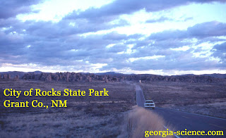
Just a couple of photos from the City of Rocks State Park in Grant Co., NM, as referenced in the previous post. It is a neat place to camp, but one time I stopped there at night to show it to a friend as we were traveling through the area. In the moonlight, the "hoodoos" were just a little too spooky.

If memory serves me correctly, these pyroclastic ash flow tuffs were erupted from the very large Emory Caldera.

Gee Whiz!

I didn't mean for an entire year to pass by without an update. Circumstances have prevented any significant field trips, will attempt to rectify this in 2015. Happy New Year!