Friday, May 27, 2011

My Head in the Clouds

Characteristics of a Scientist include...

Observation.  Imagination.  A sense of wonder.  An understanding that the Learning Curve never ends.  A hunger to learn more. A willingness to look up as well as down.

One of my side interests is the observation and photography of clouds.

"Atmospheric Optics" is an excellent site for info on clouds and other atmospheric phenomena.  There are others worthy of visits as you embark upon your self-taught journey into Nephology - the study of clouds and cloud formation.  Some of the phenomena show on Atmospheric Optics are things I will probably never see first hand, but there are others that - having been shown them - I will certainly be watching for.
This beautiful cloud was photographed in the early 1990s, looking eastward from the eastern margin of El Paso.  I would guess that the horizontal distance to the area below the center of the cloud would be about 20 - 30 miles.  My only regret is that I didn't jump into my truck and travel a bit further east to get a clearer view of the rest of the eastern sky.

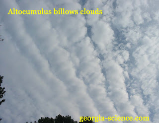
Learning about clouds is truly a challenge, as there often is an element of interpretation as to what name to apply.  There are also clouds that are combinations of two or more types.

Another challenge is the clouds are often in a constant state of flux as well as lateral movement.  Particular structures may only exist for a few seconds to minutes.  Or wind conditions may be blowing clouds away from you as you wish to gain a better view for photographic purposes.  I once spent about 20 minutes  driving through the northern Atlanta "burbs" chasing some clouds as they were blown westward.  If not for traffic lights and traffic, itself, I might have made it for a better view.  But they just got progressively further away from me the harder I tried.

When I rarely travel by air, I prefer to sit by a window with a camera to pass the time.  This image is actually from a scanned slide, originally taken by my Dad in the late 1950s/early 1960s.  It took a bit of time on Photoshop to remove dust spots and scratches. 

As time permits, I will try to post a few more photos of my favorite clouds.

Sunday, May 22, 2011

Accretionary Wedge #34 - Weird Geology

[I thought about writing about my adventures on the Georgia Coastal Plain, near the northern end of Lake Blackshear and the inability to correlate Tertiary sedimentary units from one side of Turkey Creek to the other, but that is for another story...]

Instead, the photos here are from a November 2007 visit to the northern shores of Lake Lanier, near Laurel Park, in Hall County, Georgia.  At the time, the area was in the grips of a multi-year drought.  I went to the park as the severely-declined lake surface had exposed part of the old grandstands for Looper Speedway, an old dirt track covered for the last 50+ years by Lake Lanier.  After photographing the old concrete-slab grandstands, I began to walk about a 1/4 mile or so in the opposite direction, to the north and west along the lake shore, observing the "wave cut bench" cut into the heavily weathered - partially saprolitized - metamorphic rocks (presumably old amphibolites).
In the distal portion of my shoreline "walkabout", the remnant foliation looked pretty "normal" for the Georgia Piedmont, i.e., not much distortion (as shown below).  Saprolite composes not only the wave-cut bench, but also the small wave-cut cliff.  In some places, the wave-cut cliff is composed of paleogravels from the nearby Chattahoochee River.  I dug some of the sand - from the eroded gravels - from recesses in the clayey saprolite, panned it, and found a few grains of gold.
This second photo is looking NW along the shoreline, away from Laurel Park, looking to the left in relation to the previous photo. 

Continuing southeast - back towards the Laurel Park boat landing - the geology began to get a bit "weird", with the appearance of large blobs of a "mashed" quartz/k-spar pegmatite.

A closeup of one of the pegmatite "blobs".

An axial view of the elongate blob shown in the third photo.  This pod is about 2 - 3 feet at its widest point.
This crude "flower structure" seems to suggest that the pegmatite was squeezed in a manner similar to what one might see when a tube of toothpaste has been squeezed too hard.
A slightly different view of the same structure.  There is a dramatic change in the rock "fabric" (foliation) with the fabric in the foreground at an approximate 90 degree angle to that shown to the left (behind) the "flower structure".  It would have been interesting to see this structure when the rocks were fresh, to better understand what sort of deformation we have here.

It will require some time perusing geologic maps to determine to which metamorphic unit these rocks belong.

With the recovery from the drought, the lake has returned to "full pool" conditions and these exposures are now under several feet of water.  The last time these areas were exposed was during an extended drought in the early 1980s.  I should have returned for a few dozen more photos while this area was exposed, but...