Tuesday, November 13, 2018

False Purple Thistle

Just a few thoughts on how we mature as field scientists (pardon my biases).  Partially due to my being an avid photographer, over the years of wandering about the great outdoors, I have become more observant of things besides rocks and other Geology-related things.  Having some working knowledge about plants, fungi, animals, etc. can help keep students attentive during field trips.  (After all, we ARE Earth Scientists.)

False Purple Thistle (Eryngium leavenworthii), I call it "a flower with an attitude".  I first encountered this plant on Caverns of Sonora Road, south of I-10, west of Sonora, Texas in 2016.  

It looks like a thistle, but it isn't.  It is native to KS, AR, OK, MO, TX, and WI and it seems to prefer limestone-based soils (as seen by this specimen on the Edwards Plateau, west of Sonora, TX).  It is usually found in rocky prairies and open woods.  The nectar is good for pollinators and the seeds serve as food for birds.
Resources:

False Purple Thistle - Lady Bird Johnson Wildflower Center
False Purple Thistle - Weedin, Waterin, Watchin Blog

A Two-Part Post...

Over at Itinerant Geologist on "Road Food", based upon my travels between Georgia and Arizona in 2015, 2016, and 2017.

Part 1 - Today

Part 2 - November 14

Part 3 - TBA

As we have to eat, while we travel, right?

Saturday, November 3, 2018

Another Geology Blog...

...To be added to the Blogroll.

Geotripper.  Done by a California Geology teacher.

Go have a look.

Friday, October 19, 2018

Another Cool Geology Website

From Geologist James St. John of Ohio State University.

He also has a large number of science photos posted on flickr.  A mixture of Geology and Biology, with a good supply of explanations.

Go "have a look".

Thursday, October 18, 2018

Found an Interesting Blog a Few Days Ago

Dave'n'Kathy's Vagabond Blog, it is a travel blog with some Geology amidst the numerous nature photos and travel dialogue.

Drop by and "give a look".

Wednesday, October 17, 2018

Plant Life...in the Eagle Mountains

As seen during my 1978 fieldwork in the Eagle Mountains.  There were - no doubt others - but not being as observant as I am now, I missed them.


On the slopes of the mountains, as in the East Mill area, there were Junipers, Mesquite, Cholla, Prickly Pear, and Creosote Bushes.  In the higher, cooler areas there were scrub oaks, in sheltered lower areas there were pine trees and grasslands.  One valley even hosted some muscadine (wild grape) vines.

In the Temperate Chihuahuan Desert, isolated mountain ranges are referred to as "Islands of Diversity" or "Sky Islands".  The Orographic Effect yields more rainfall for the mountains in contrast to the surrounding flatter areas and where there are valleys, the morning and afternoon shading helps entrap moisture when it does rain.  Additionally, the eastern slopes of these mountain ranges tend to be greener, as the cooler morning sun causes less evaporation in contrast to the hotter, western slopes with their afternoon sun.

All of these factors - along with variations in slope and altitude and cooler temperatures due to higher elevations - produce a diverse array of Micro-Climates and Micro-Ecosystems, thus the name "Islands of Diversity".

This phenomenon is also well displayed in the Davis Mountains to the east.


Tuesday, October 16, 2018

It's Already Been 40 Years...Just Damn - Part 1


It's been forty years since I spent 10 weeks of the summer in the Eagle Mts. of Hudspeth County, Texas.  [From a few miles away, at the I-10 Allamoore - Hot Wells exit, the Eagle Mountains don't seem so imposing, but once past the outer rampart of hills, it was quite the adventure in 1978.]  

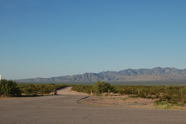
In the photo, the southern "half" of the east side of the mountains is shown, with Eagle Peak being the highest point near the right margin of the photo.  The low hills (on the left) and the low ridge (on the right) that make up the eastern margin of the mountains consist of Cretaceous sedimentary rocks, probably remnants of the Laramide thrust sheet upon which the caldera was superimposed.  The area was later modified by Basin and Range faulting as well.  In the foreground is Eagle Flat, which occupies most of the area east of Sierra Blanca and west of the Carrizo Mountains.

The Eagle Mountains were the site of my originally-planned Master's Thesis.  (Sometimes, when I get nostalgic/ melancholic, I go back to the Eagle Mountains in my mind, as I did here.)  Because of intervening "life events", I never got that project finished, but later did a Thesis west of El Paso, associated with the Quaternary Aden Crater basalts.

I was part of a group of four UTEP Geology grad students working on the Oligocene caldera that forms the core of the Eagle Mountains.  Due to its size, the volcanic core was divided into quadrants. As the topographic maps suggested that the southern "half" of the mountains was more rugged than the northern "half" and I had the only 4x4 vehicle (below), it was decided that I would do the SE quadrant and my field partner Dan would do the SW quadrant.


During my 10 weeks in the Eagle Mountains, my truck camper was my home.  No A/C, no "indoor plumbing" (further details not needed), but with power steering, a manual transmission, and 4-wheel-drive, in its youth, my 1976 Jeep J-10 was a pretty good field vehicle for off-pavement use.  After this 1977 photo, my Dad and I added a sliding rear window to the truck cab and an inflatable "boot" to seal the gap between the cab and camper to allow inclement-weather passage.

Usually, Dan and I would head into Van Horn for supplies every 4th day or so, as supplies of ice, food, and gasoline would only last that long.  The roads were rugged enough that I was almost constantly grinding around the roads in 1st gear and 4-wheel-drive, reducing the truck's bad gas mileage (12 mpg) even more.

In the northern "half" of the mountains, Mike was doing the NE quadrant and Bob was doing the NW quadrant.  The first day or so that we were in the mountains, Dan and I hung out in the northern "half" of the mountains with Mike and Bob, just to get acquainted with the terrain and the existing geologic map we were using as a reference.

Once we had checked in at the Eagle Mountains ranch house, we followed the winding roads northward between the hills within the NE quadrant.  As we drove over the hills and were out of sight of the ranch house, perhaps without realizing it, we were being introduced to the concepts of "Orographic Lifting" and "Micro-Climates", without realizing it.  Within nearby Eagle Flat, that we crossed on our way to the mountains, the dominant plant was Creosote Bush (Larrea tridentata) along with other typical Chihuahuan Desert plants.  In contrast, the area in which we were driving was an actual grassland with pine trees (the limb of one pine tree removed my right side mirror and radio antenna)

[To be continued: in Part 2]

References:
Underwood, James R., 1980  Geology of the Eagle Mts., Hudspeth County, Texas.


Monday, October 15, 2018

Advisory

Begging your pardons, as I attempt to get back to regular blogging here and on the companion blog "Itinerant Geologist", I find that I am bedeviled by format changes in Blogger.

It is somewhat different from my original postings from approximately 2007 to 2011 (+/-).

Hopefully, I will become acquainted "how it is", soon.

A Couple of New Posts at Itinerant Geologist

The first post sets the stage and the context for posting photos from four Atlanta to Phoenix roundtrip photos from 2015 (two trips), 2016 (one trip), and 2017 (one trip).

The second post is on the first two days of 2015 Arizona Trip #1.

The intent is to use the other blog as the "travel blog" while covering individual stops (past, present, and future) on this one.  Or random subjects/memories not related to recent travels, "as the spirit moves me".

[For what it's worth when I can, I prefer to drive on journeys, to allow for photography and "getting the feel" of the land.] 

Saturday, June 16, 2018

African Rue, an Invasive Species


As I go through photo files of 2015 & 2016 travels, some plants resist identification.
African Rue (Peganum harmala) is one of these. It is an Invasive Species, apparently brought to the Deming, New Mexico area about 1930, for possible use as "Iranian red" dye.
The plant decided it liked the area so much, it started to spread, primarily through southern New Mexico, West Texas, Arizona, and parts of California and Oregon. 

It is toxic to humans and livestock, but livestock usually avoid it because of its bad taste, unless they are sick or starving. Apparently, studies of the toxic seeds by pharmaceutical companies suggest a possible use as an antidepressant.
Because of its characteristic deep taproots, it is difficult to uproot. And it is a prodigious producer of seeds.
Now that I have learned about this plant, the soft "frilly" leaves seem to be a good identifier, though Tumbleweed (aka Russian Thistle) - also invasive - sort of have "frilly" narrow leaves, too.
(This particular photo was taken in 2015 at the I-10 Allamore - Hot Wells exit, east of Sierra Blanca.  This exit is the one for the Eagle Mts.)
Resources:


Monday, June 11, 2018

As the Spirit Moves Me...

Not to make excuses for my absences,...

Years ago, I used to have the idea that, as I got older, "life would be simpler", as I would "have everything figured out".  Not a chance.

Anyway, when I began teaching at a junior college in 2001, I started leading short on-campus "field trips", in lieu of the class routines in my Geology and Environmental Science classes.  The particular campus on the Georgia Piedmont was adequate for Physical Geology (metamorphic rocks, erosion, soils, creek dynamics, geomorphology) and even better for Environmental Science.

I found that in order to more effectively retain student attention in the Environmental Science field trips, I needed to teach myself more about the local flora and fauna, as well as the "local" Exotic Species.  In other words, I needed to become more well-rounded in my science knowledge.  (This would be beneficial a few years later when my son entered Cub Scouts and then Boy Scouts.)

As college-level teaching and being an Assistant Scoutmaster are now - apparently - in my past, I still retain a strong drive to continually learn more about aspects of nature beyond "just Geology", i.e., when time permits, I spend as much time photographing wildflowers (and other living things) as I do photographing Geology.

Thus "as the spirit moves me", I plan to post random wildflower, bird, bug, mushroom,...photos, as these living things are important components of their respective ecosystems.  As plants form the "base" of every consequential ecosystem and local food web, the soil often influences the local plant community.  Common and scientific names will be included to facilitate further internet searches.

Sunday, May 20, 2018

Geo-Learning

It goes on daily.  

Or at least I try to learn something daily, whether it be Geology, Biology, Ecology, Environmental Science, Photography, Botany, History,...

(Whisper, whisper,...this is to partially-offset what has been forgotten over the years.)

Yesterday, it was the Vulcanology-related use of "boca" (Spanish for "mouth").  My first exposure to the term was at Capulin Volcano in northeastern New Mexico in the summer of 2015.

There is a good resource available, "High Plains of Northeastern New Mexico: A Guide to Geology and Culture", New Mexico Bureau Geology & Mineral Resources; Scenic Trip Series, Number 19.  (2005) Muelhberger, Muehlberger, and Price.

(Screenshot below from this source.)


High plains of northeastern New Mexico : a guide to geology and culture

Originally, I purchased this book while planning a 2009 summer vacation for my first wife, son, and me.  After visiting relatives in NW Oklahoma, the plan was to go a bit "beyond there", as finances and time permitted.

But "as we make our plans, life happens".  As the summer of 2009 approached, my son in-law had a job interview in NYC and my daughter didn't want to be left alone at home with a 3 month-old son.  So she planned to drive her SUV with my wife and I rented a Plymouth PT Cruiser for my son and I to caravan to Oklahoma and back.  [The "NYC gig" lasted for about two years, deemed to be good for a short bit, but too expensive.  So they came back to Georgia.]

On the 2009 journey, as 3 month-old Ben was not used to be in a car seat for long distances, he screamed incessantly, frazzling my daughter, the new Mom.  Frequent stops were necessary, as she didn't know if he was hungry, wet, dirty, or just dissatisfied with the car seat with his vocal protestations.  We got to Oklahoma to see the inlaws and so they could meet their first great-grandchild.

Not wanting to be on the road for longer than needed, the NM trip was nixed.  And my absorption of the book was no longer needed.

As we planned to go by Dallas on the way back to see more relatives and frequent "Ben stops" were necessary, once we got to I-35 south of Oklahoma City, my son and I were able to take the short back road (US Hwy 77) through the Arbuckle Mts. and I did get some "geo-photos" and a few rock samples (pictures in a later post), before we hooked back up via cellphone.

After returning to Georgia, the book went back on the shelf until the tumultuous summer of 2015.  In the interim, my only thought about the discarded plans were "I want to visit Capulin Volcano, someday".

(Story to be continued on "Itinerent Geologist", soon.)

Wednesday, March 21, 2018

Memory Lane Visit

Lurching down Memory Lane, when one memory triggers another...(don't know why sometimes.)
Twenty years ago, while still working for the Georgia Geologic Survey, we were redirected to complete a USGS-funded stream sediment study across the southernmost tier of Georgia counties, from the Alabama line to the Atlantic Coast, perhaps comprising 20% of Georgia's 159 counties.
If memory serves me correctly, it was to study the trace minerals, i.e., minerals which contained rare elements, within the stream sediments we collected. There were EPD employees from various branches. (Though it was during January and February, it was a welcome break from the routine for a few weeks.)
The particular memory was of one of my GGS coworkers being paired up with a Biologist from another EPD branch. Now as I have been a beer can collector, as well as a general packrat for decades, I sometimes pick up old stuff while in the field. Nothing unusual there, though I think this particular coworker didn't have any "side hobbies" as I do and I gathered that he "looked down his nose" at my "low brow" collecting interests.
Perhaps as some sort of karmic payback, my coworker was paired up with a female Biologist that had an interesting "side hobby". She like to gather fresh (or relatively fresh) roadkill, take her treasures home, boil them down to retrieve the bones and reassemble the skeletons.
I was using an EPD pickup truck with a hinged bed-cover, while my coworker was using some sort of EPD passenger car. This is important, as while my sediment samples (and any old beer cans and such) went into the bed of the pickup, the Biologist's dead animals went into the trunk of the car (into a Styrofoam cooler, which isn't air-tight). Over the course of each week, she picked up several dead critters that added their "aromas" to the ambiance of the car, resulting in the need to keep the windows open.
Each morning, we gathered at the motel as I gave them their maps and suggested collecting locales for the day (on a grid pattern). When this coworker complained about his field partner's collecting habits, I couldn't help but ask him which he preferred, my old rusty beer cans or her dead animals, which triggered an epiphany for him, as he gave me a look which said: "Do you even have to ask?". (I was no longer the craziest person he knew. I think he did manage to get her assigned to another vehicle for the last week or so.)

Tuesday, March 6, 2018

Xenoliths

Aside from being a nifty word for Scrabble, "Xenolith" is an important component of the concepts of "Inclusions" and "Relative Age Dating". 

For a quick review, a Xenolith is a piece of pre-existing rock that "falls" into a body of magma in which the temperatures are not high enough to assimilate the "foreign rock".  As the xenolith is an already-solidified piece of rock, it is older than the "host magma" (or lava) into which it falls.  Thus, within the xenolith/host rock relationship, the inclusion (xenolith) is always older than the host rock.

My best luck at collecting Xenoliths has been in Kilbournes Hole, New Mexico, and the Eagle Mts., Texas (decades ago) and the backlot of a granite monument cutting business, west of Elberton, GA (below and next post).

In this particular Franklin Mts. outcrop (below), there are at least two sets of Xenoliths, the black basalt/diabase blocks, and the greenish-gray contact-metamorphosed limestone, both of which "fell" into the Proterozoic Red Bluff Granite magma. 
 
This second photo, immediately west and uphill of the above, shows remnants of a larger Castner Marble (limestone) xenolith.

This photo is of a xenolith in the East Quarry area of Stone Mt., Dekalb County, Georgia.
 This particular xenolith is from the Elberton Granite.  [This image was "squared-off" - using Photoshop - for education purposes.]
In the case of the Mantle, Xenoliths erupted in "volcanic bombs" at Kilbournes Hole, New Mexico, the ultramafic fragments were carried upward by the basaltic magma and erupted in a "Maar Volcano" setting.

Previous posts about the subject:

Kilbournes Hole, NM 

What a Geologist Sees - Part 3

What a Geologist Sees - Part 13

What a Geologist Sees - Part 14

Boulder xenolith, Eagle Mts., TX