[Subtitled: Geophotos, Memories, and Hopes. Please excuse any leftover 2010 formatting glitches and inconsistencies.]
Within my geophoto database, the photos that are among my favorites include those from the Eagle Mts. (West Texas), the Bisti Badlands (San Juan Co., NM), and Monument Valley (UT/AZ). [The labeled photos have been used in some of my classroom Power Point presentations.]
Figure 1.
Yeah, I got a bit carried away going down memory lane.
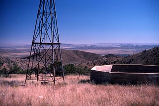
The Eagle Mts. (an Oligocene caldera) were the site of my originally-intended Master's Thesis work, during the summer of 1978. The 1st photo here was taken from the East Mill area, where we camped while we mapped the southeastern portion of the mountains. In the near foreground is a portion of Wyche Ridge, composed of Cretaceous sedimentary rocks, forming part of the margin of the caldera.
Eagle Flat is in the middleground and the Carrizo Mountains are in the background (and maybe the Beech Mountains and/or the Sierra Diablo in the far background, too). Alamo Springs may be visible from this location, also.

Figure 2.
This was one of the few close-up photos of the pyroclastic textures that I took that summer. I guess I planned to get more in future trips, but I got "distracted" by events in my personal life and never finished this project.
(I did start another thesis project in 1985 in the Aden Volcanic Field). I would, love the opportunity to take my son 4-wheeling back in the Eagle Mts., - maybe someday. To enjoy the quiet and get a few more photos and maybe find that rock hammer that I lost, the one I was given by my Dad when I went off to Grad School.
Figure 3.
The Bisti Badlands in San Juan County, NM were the site of a 1979 summer job. I was hired to assist in a "fossil recovery project", locating Cretaceous vertebrate, invertebrate, and permineralized wood samples, prior to the opening of a coal mine.
Figure 4.
During the early part of my six weeks there, I took hundreds of slides, then unbeknownst to me, the shutter on my Miranda camera jammed.
It rained almost every day the first two weeks we were there and the clays in the Fruitland Fm. are like grease when they get wet. After that first two weeks, I don't recall anymore rain for the remaining four weeks of the project.

Figure 5.
The primary goal of our project was to mark the location of every dinosaur bone in two and a half square miles, recover all loose bone fragments, then leave the removal of large pieces to the University of New Mexico.
Sometimes when I talk about being a Geologist to a bunch of kids, I tell them about the summer "I got paid to look for dinosaur bones", which usually catches their attention. We were supposed to continue this same project in the summer of 1980, but the permits between the state and federal land didn't get resolved in time. I would have enjoyed another go-round in this area.

Figure 6.
It has been years since I read any reports generated by this project, but I seem to remember my lead professor telling us that most of the bones we found were of hadrosaurs (duck-billed dinos). We also found turtle shells fragments, crocodile scutes, and a few fresh-water bivalves (the ecosystem had been an Everglades sort of setting).

Figure 7.
It was always fun to find one of these areas just littered with permineralized logs, though they were not generally as colorful as the wood from the Petrified Forest.

Figure 8.
I hope this stump was retrieved for a museum or at least given a place of honor outside of a college classroom building.
Figure 9.
The site where I collected this "clinker zone" shale (actually outside of our study area), with the plant fossils is one of those places that I regret not having collected more samples from. I only picked up two pieces and gave one away during the intervening years. I wish I had filled a bucket.
Figure 10.
Monument Valley is a place I had not yet visited (until 2015), but someday hope to. My geophotos from Monument Valley are scanned slides taken in the summer of 1980 - by my Dad - when he and my Mom were on their last vacation together. He passed away in November 1980.
Figure 11.
Figure 12.
I use these photos, along with my photos of Canyonlands NP and the Grand Canyon when discussing Colorado Plateau stratigraphy and when discussing arid-climate weathering and erosion characteristics and when discussing things like eroded volcanic necks.

Figure 13.
Other stops on that trip included the Painted Desert/Petrified Forest,...
Figure 14.
...and Dinosaur National Monument,...
Figure 15.
...Yellowstone, ...
Figure 16.
...and the SD Badlands.
My Dad was not a Geologist, but he (and my Mom) did enjoy learning about new things and being outside. I will forever be thankful that he got me interested in photography.


No comments:
Post a Comment